


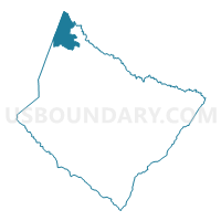
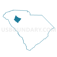
Cooks Voting District, Laurens County, South Carolina
About
Outline

Summary
| Unique Area Identifier | 666207 |
| Name | Cooks Voting District |
| County | Laurens County |
| State | South Carolina |
| Area (square miles) | 20.85 |
| Land Area (square miles) | 20.73 |
| Water Area (square miles) | 0.13 |
| % of Land Area | 99.39 |
| % of Water Area | 0.61 |
| Latitude of the Internal Point | 34.72294040 |
| Longtitude of the Internal Point | -82.14380620 |
Maps

Graphs
Select a template below for downloading or customizing gragh for Cooks Voting District, Laurens County, South Carolina


Neighbors
Neighoring Voting District (by Name) Neighboring Voting District on the Map
- Fountain Inn 1 Voting District, Greenville County, SC
- Jones Voting District, Laurens County, SC
- Owings Voting District, Laurens County, SC
- Walnut Springs Voting District, Greenville County, SC
- Woodruff American Legion Voting District, Spartanburg County, SC
- Woodruff Fire Station Voting District, Spartanburg County, SC
- Youngs Voting District, Laurens County, SC
Top 10 Neighboring County Subdivision (by Population) Neighboring County Subdivision on the Map
- Simpsonville CCD, Greenville County, SC (47,859)
- Gray Court CCD, Laurens County, SC (16,330)
- Fountain Inn CCD, Greenville County, SC (11,560)
- Woodruff CCD, Spartanburg County, SC (10,919)
Top 10 Neighboring Place (by Population) Neighboring Place on the Map
Top 10 Neighboring Unified School District (by Population) Neighboring Unified School District on the Map
- Greenville County School District, SC (466,178)
- Laurens School District 55, SC (37,250)
- Spartanburg School District 4, SC (18,439)
Top 10 Neighboring State Legislative District Lower Chamber (by Population) Neighboring State Legislative District Lower Chamber on the Map
Top 10 Neighboring State Legislative District Upper Chamber (by Population) Neighboring State Legislative District Upper Chamber on the Map
- State Senate District 8, SC (111,941)
- State Senate District 9, SC (95,114)
- State Senate District 13, SC (92,248)
Top 10 Neighboring 111th Congressional District (by Population) Neighboring 111th Congressional District on the Map
Top 10 Neighboring Census Tract (by Population) Neighboring Census Tract on the Map
- Census Tract 9201.01, Laurens County, SC (7,014)
- Census Tract 31.01, Greenville County, SC (6,787)
- Census Tract 30.09, Greenville County, SC (5,290)
- Census Tract 235, Spartanburg County, SC (4,909)